
Imagine opening a website that lets you explore aircraft movements, ships, satellites, natural disasters and other real-world activity on an interactive map. It sounds like something from a spy movie, but open-source technology is making geospatial intelligence more accessible than ever.
One interesting project to explore is God’s Eye View, an open-source geospatial visualization project available on GitHub. Beyond exploring the platform, you can use it as inspiration to build location-based dashboards, research tools and business services with AI.
And here’s the exciting part: you do not need to spend months mastering JavaScript, APIs or mapping libraries before getting started. With AI coding assistants and a technique called vibe coding, beginners can build prototypes by describing what they want in plain English, letting AI generate code, and testing the results step by step.
In this guide, you will learn how to set up God’s Eye View, use AI to build geospatial applications, explore five business ideas, and develop a practical plan to target your first $2,000 in revenue.
TLDR: scroll down to the bottom of the webpage
1. What Is God’s Eye View, and How Do You Install It?
God’s Eye View is an open-source project that explores geospatial data through an interactive, map-based interface. Depending on the available integrations and data sources, platforms in this category can visualize aircraft, maritime activity, satellite information, environmental events and other geographic data.
It is important to understand that public data visualizations are not the same as classified intelligence. Data availability, accuracy, update frequency and access restrictions vary by source. Some features may also require additional configuration or API credentials.
How to set up God’s Eye View on your computer
You can start by following the installation instructions in the project's official GitHub repository.
Step 1: Install the prerequisites
Check the repository's README for the current requirements. You may need Git, Node.js and a code editor such as Visual Studio Code. If you are unfamiliar with these tools, ask an AI assistant to guide you through installing them on your operating system.
Step 2: Download the project
Open the project’s GitHub page and look for the installation instructions. If the project supports installation through a desktop installer or a tool such as Pinokio, follow the documented process.
Alternatively, if the repository recommends a terminal-based setup, the general process may look like this:
git clone https://github.com/bilawalsidhu/gods-eye-view.git
cd gods-eye-view
npm install
Only run commands that match the project's current documentation. The commands above illustrate a common setup pattern, and the repository's requirements may change.
Step 3: Let AI guide you
If the installation fails, do not spend hours searching through technical forums. Copy the exact error message into ChatGPT or Claude and ask for the next troubleshooting step.
Try this prompt:
I am a beginner installing the God’s Eye View project from GitHub. Read the relevant installation instructions I provide and guide me one step at a time. Explain every command in plain English. Do not assume I have technical knowledge. If something fails, diagnose the exact error before suggesting the next step. Never ask me to expose passwords, private keys or API secrets.
Step 4: Explore the interface
Once the project is running, explore its available map layers, controls, filters and visualizations. Identify what the application does well and where users might need something more useful, simpler or tailored to a specific industry.
That last step matters. You are not merely learning to operate a website. You are looking for a problem that a paying customer might want solved.
2. Build Geospatial Apps Using AI and Vibe Coding
Traditionally, building a geospatial application required learning programming, APIs, data formats, mapping libraries and deployment. That can be a long journey for someone whose real goal is to start a business.
AI-assisted development offers a different approach.
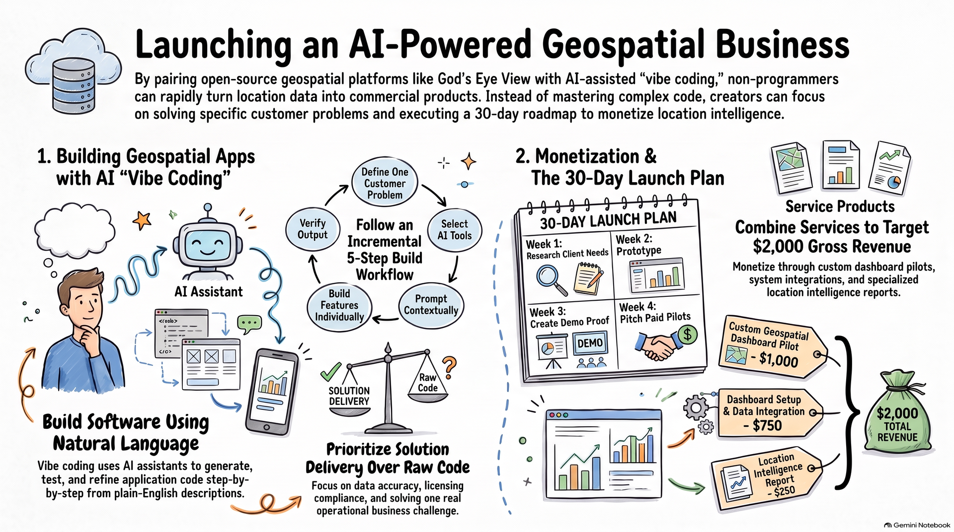
Vibe coding means describing an application in ordinary language, using AI to generate or modify its code, and improving it through repeated testing. You act as the product thinker and project director while AI helps with much of the implementation.
You still need to verify the output, but you do not have to become an expert programmer before building your first prototype.
A beginner-friendly AI development workflow
Step 1: Choose a specific problem
Avoid starting with the ambition to recreate an entire intelligence platform. Choose one customer and one useful outcome.
For example, a logistics company might want a dashboard showing delivery locations, delayed routes and weather disruptions.
Step 2: Choose an AI coding assistant
Begin with one tool rather than trying everything at once.
ChatGPT or Claude: Plan the product, generate code, explain errors and improve features.
Replit: Build and run applications in an online development environment.
Bolt.new or Lovable: Help generate web application prototypes from natural-language instructions.
Features, pricing and integrations vary across these tools. Check their current plans before committing to a paid subscription.
Step 3: Describe the application you want
You can start with this reusable prompt:
Act as my AI product developer and coding partner. I am a beginner with no programming experience. Help me build a simple geospatial web application inspired by the God’s Eye View project.
My target customer is [describe the customer], and the problem I want to solve is [describe the problem].
Build the simplest working prototype first. Use an appropriate mapping library and legitimate, documented data sources. Generate the code, explain how to run it, and troubleshoot errors one at a time.
Add features incrementally, such as search, filters, location markers, alerts and downloadable reports. Verify data accuracy and attribution. Explain API costs, usage limits, security risks and any limitations. Never expose secret API keys in frontend code or commit them to a public repository.
Keep explanations beginner-friendly. Prioritize a working demo that solves one real problem over unnecessary features. Ask me only for information needed for the next step.
Step 4: Build one feature at a time
Ask AI to create the basic map first. Then add one feature, test it, and move on.
For example:
Display a map with a few sample locations.
Add search and category filters.
Connect a legitimate public data source.
Show relevant details when a user selects a marker.
Add an exportable report or notification.
Deploy a demo for potential customers to test.
If AI generates code that does not work, share the error and ask it to diagnose the cause. Avoid asking it to rebuild the entire application every time something breaks.
Step 5: Verify before selling
AI-generated software can contain bugs, incorrect assumptions and security vulnerabilities. Confirm that the data is genuinely available, properly licensed for your intended use, and sufficiently accurate for the customer’s decision.
Start with public or synthetic demonstration data. Do not use the tool to track private individuals, bypass access restrictions or make unsupported claims about what a map reveals.
You do not need to master every technical detail before beginning. However, you must understand enough to test the application, explain its limitations and know when you need a qualified developer.
3. Five Geospatial Business Ideas and How to Target $2,000
The business opportunity is not necessarily selling access to a map. It is helping a customer make a better decision using location-based information.
Here are five ideas you can explore with AI-assisted development.
1. Logistics and fleet intelligence dashboards
Potential customers: Small logistics companies, distributors and fleet operators.
Build a dashboard that brings together authorized vehicle-location data, delivery status, route information and relevant weather alerts.
How to sell it: Contact local logistics businesses and ask how they currently monitor delays or coordinate deliveries. Offer a small paid pilot that addresses one clearly defined problem.
Start with data the business already owns or is authorized to share. Do not promise real-time tracking unless the underlying data supports it.
2. Environmental monitoring and risk alerts
Potential customers: Environmental consultants, agricultural businesses, infrastructure operators and research organizations.
Combine legitimate public information about rainfall, floods, fires, air quality or other environmental indicators into a dashboard relevant to a specific region.
How to sell it: Create a sample report for one district or business location. Demonstrate how the information could support planning, risk awareness or operational decisions.
Present alerts as decision-support information, not as guaranteed predictions.
3. Maritime and port intelligence reports
Potential customers: Maritime consultants, shipping-related businesses, logistics analysts and researchers.
Use appropriately licensed maritime and port information to summarize activity, congestion indicators or regional developments.
How to sell it: Prepare a sample report for one port, identify a specific business question, and offer recurring research or a custom dashboard if the customer sees value.
Public ship-tracking data may have coverage gaps, delays or licensing restrictions. Never assume that every vessel is visible.
4. Real estate location intelligence
Potential customers: Property consultants, commercial real estate firms, retail businesses and investors.
Develop location-based reports comparing factors such as connectivity, nearby amenities, public infrastructure and available demographic information.
How to sell it: Create a sample report comparing two commercial locations. Explain the factors, sources and limitations, then offer customized reports to brokers, retailers or property consultants.
This is particularly useful when the client needs a clearer way to compare locations, rather than another generic property listing.
5. Geospatial research and dashboard agency
Potential customers: Startups, NGOs, research teams, consultants and businesses that need location-based analysis.
Offer a combination of data research, interactive maps, custom dashboards and recurring reports. AI can help you create prototypes and automate repetitive work, while you focus on customer requirements and quality control.
How to sell it: Pick one niche, build two credible demonstrations, and contact prospective clients with a specific offer. For complex production systems, partner with an experienced developer instead of attempting to handle every technical and security requirement yourself.
How can you target your first $2,000?
Treat $2,000 as a business target, not a guaranteed outcome. Your timeline will depend on your skills, market, sales ability and the value you deliver.
A possible revenue mix is:
| Service | Illustrative price |
|---|---|
| Custom geospatial dashboard pilot | $1,000 |
| Dashboard setup and data integration | $750 |
| Location intelligence report | $250 |
| Total gross revenue | $2,000 |
These are example prices, not verified market rates. Your actual pricing should reflect the client's budget, project complexity, data costs, delivery time and competing alternatives. Gross revenue is not profit and excludes expenses and taxes.
A practical 30-day action plan
Week 1: Explore and choose
Install or explore God’s Eye View using its official instructions. Select one customer category and interview at least five potential buyers. Find out what decisions they make, what information they lack and how they currently solve the problem.
Week 2: Build a prototype
Use an AI coding assistant to create a small application around one problem. Keep the first version simple. Use sample data or a legitimate public data source, and avoid unnecessary paid integrations.
Week 3: Create proof
Prepare a short demonstration video, screenshots and a sample report. Show how your application saves time, organizes information or supports a specific decision. Ask prospective customers to critique it.
Week 4: Pitch a paid pilot
Reach out to relevant businesses through LinkedIn, email, industry communities and your existing network. Offer a clearly scoped pilot with defined deliverables, timelines, costs and limitations. Aim to secure a paying customer, learn from the response and improve the offer.
Do not spend the entire month perfecting the technology before speaking to buyers. Customer feedback should determine what you build next.
Final Thoughts
God’s Eye View can be a useful starting point for exploring open-source geospatial technology. But you do not need to reproduce the entire project to build a business around the same general opportunity.
Use AI to reduce the technical learning curve. Start with a narrow problem, build a working prototype, verify your data and test whether a real customer will pay for the outcome.
Your competitive advantage will not come from simply having access to AI or a map. It will come from understanding a customer's problem, delivering a reliable solution and learning how to sell it.
Link: Explore the project: https://github.com/bilawalsidhu/gods-eye-view
Start small. Build with AI. Validate with customers. Then scale what works.